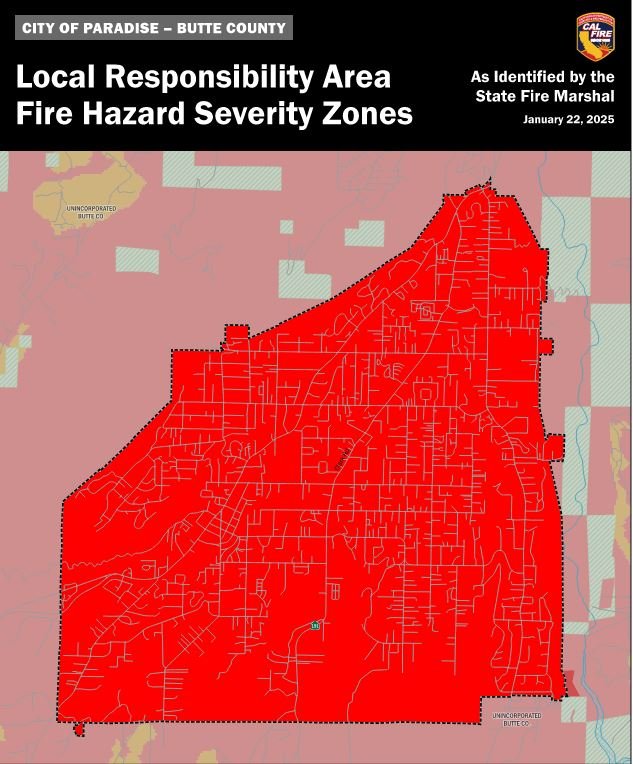
Fire Hazard Severity Zone Map
Local Responsibility Area (LRA) Fire Hazard Severity Zone Update (FHSZ) - Introduction
Welcome to the information hub for the update on the Town of Paradise Fire Hazard Severity Zone (FHSZ). This site provides detailed information about the rollout of updated fire hazard severity zones within the Town of Paradise's Local Responsibility Areas (LRA). As Government Code Section 51178.5 requires, the Town is mandated to ensure public access to the proposed maps and facilitate a public comment period.
The public needs to understand that these maps are created by the California Department of Forestry and Fire Protection (CAL FIRE) under the guidance of the State Fire Marshal. The local agencies, including the Town of Paradise, do not control the creation of these maps but provide opportunities for community review and feedback.
Under the California Government Code Section 51179(a), local agencies must designate moderate, high, and very high fire hazard severity zones within 120 days of receiving recommendations from the State Fire Marshal, according to Section 51178. Local governments are not permitted to adopt a map that lowers the FHSZ rating designated by the Office of the State Fire Marshal (OSFM); they can only adopt a map as presented or modify it to raise the rating to a higher threat level.
These maps are crucial for land use planning, enforcing building codes, and developing wildfire risk mitigation strategies. Public input is essential to address concerns, validate data, and enhance understanding of how these zones affect residents, businesses, and emergency response planning.
We strongly encourage all residents and stakeholders to examine the proposed maps, ask questions, and submit their feedback. Your participation is crucial in this state-mandated process and is key to ensuring our community is safer and better informed.
Authorities & References
Government Code 51178: The State Fire Marshal must identify areas in the state as moderate, high, and very high fire hazard severity zones based on consistent statewide criteria and the expected severity of fire hazards. These designations consider fuel loading, slope, fire weather, and other relevant factors, including areas where the State Fire Marshal identifies wind as a significant factor in spreading wildfire.
News & Additional Information
The 90-day public comment period opened 2/12/2025. If you have any questions about the maps and the process, contact the Office of the State Fire Marshal at FHSZinformation@fire.ca.gov or by calling (916) 633-7655.
Resources and Additional Information
Fire Hazard Severity Zones | OSFM (Link) https://osfm.fire.ca.gov/what-we-do/community-wildfire-preparedness-and-mitigation/fire-hazard-severity-zones
Insurance Commissioner Q&A (PDF) see attached
LRA Legislation Factsheet Flipbook (Link)https://www.paperturn-view.com/cal-fire-communications/lra-legislation-factsheet-flipbook-combined?pid=ODg8841799&v=4